Powerful & Shocking: Earthquake in Cebu Philippines (Magnitude 6.9) — Impact, Timeline, and Recovery
A comprehensive, expert briefing on the earthquake in Cebu Philippines—its magnitude, timeline, victims, damage, aftershocks, and what comes next for Central Visayas.
Primary live reporting stream:
BBC News live updates on the Philippines earthquake.
This article consolidates verified details from official bulletins and major wire services to give readers a professional, blog-style overview of the earthquake in Cebu Philippines
Executive Summary
On 30 September 2025 at 21:59 local time (PST, UTC+8), a shallow magnitude 6.9
earthquake in Cebu Philippines struck offshore near Bogo City in northern Cebu. According to PHIVOLCS and corroborating international outlets, the quake’s shallow depth—around 5–10 km—intensified ground shaking across Central Visayas, triggering landslides, structural failures, and widespread power loss.
As response efforts progressed, officials reported at least 72 fatalities and more than 300 injuries,
while the broader impact touched an estimated 170,000+ residents across Cebu’s northern municipalities. Damage assessments noted 87 buildings and nearly 600 houses damaged or destroyed, with critical hits to local churches, schools, a sports complex, and sections of transport infrastructure.
Core Facts at a Glance
- Magnitude: Mw 6.9 (moment magnitude).
- Time: 21:59:43 PST (UTC+8) on 30 Sept 2025.
- Epicenter: Offshore, NE of Bogo City, Northern Cebu, shallow depth ≈5–10 km.
- Victims: At least 72 dead; 300+ injured; 170,000+ affected.
- Damage: 87 buildings & ≈600 houses damaged/destroyed; notable heritage and public structures affected.
- Aftershocks: Thousands recorded in subsequent days, including felt events across Northern Cebu.
Why This Earthquake Was So Destructive
Several factors combined to make the earthquake in Cebu Philippines unusually destructive. First, the quake struck at night, which increased vulnerability as households were indoors and visibility was poor; consequently, evacuations were slower and confusion higher. Second, the shallow depth amplified surface shaking even at moderate distances from the epicenter. Third, the event occurred soon after severe weather in parts of the Visayas, leaving slopes saturated and therefore more prone to landslides.
Moreover, PHIVOLCS notes the event ruptured a previously unmapped or long-dormant offshore fault segment, underscoring the complexity of regional tectonics around the Philippine Mobile Belt. Inevitably, that discovery will drive new hazard maps and retrofitting priorities for Northern Cebu in the months ahead.
Minute-by-Minute: Timeline of the Quake and Its Immediate Aftermath
- 21:59 — Mainshock hits off Bogo City (Mw 6.9). Power interruptions and communications drop are reported minutes later across several barangays.
- 22:05–22:30 — Initial felt reports arrive from across Central Visayas; responders scramble as landslides and building collapses emerge in northern Cebu’s coastal and upland communities.
- ~23:00 — Local authorities begin evacuations and establish ad-hoc triage near municipal halls and schools; aftershocks are recorded through the night.
- Overnight — Conflicting casualty figures gradually consolidate; hospitals report surge conditions and move vulnerable patients outdoors due to aftershock risk.
- Following day — National leadership visits the affected zone; a state of calamity is discussed while relief pipelines activate.
Human Impact: The People Behind the Numbers
Statistics convey scale, but stories reveal consequence. Families in Bogo, Daanbantayan, San Remigio, and Medellin describe frantic escapes through darkness, with aftershocks complicating rescue efforts and rain making already-unstable slopes dangerous. Heartbreaking accounts include youth and parents shielding siblings and children during landslide events triggered by the earthquake in Cebu Philippines.
At evacuation centers, the priorities are predictable yet urgent: water, latrines, medical assistance, safe spaces for infants and new mothers, and charging points for phones so families can coordinate reunions and access official updates. Consequently, psychosocial support is being requested alongside food and shelter kits as communities process grief and fear of continuing aftershocks.
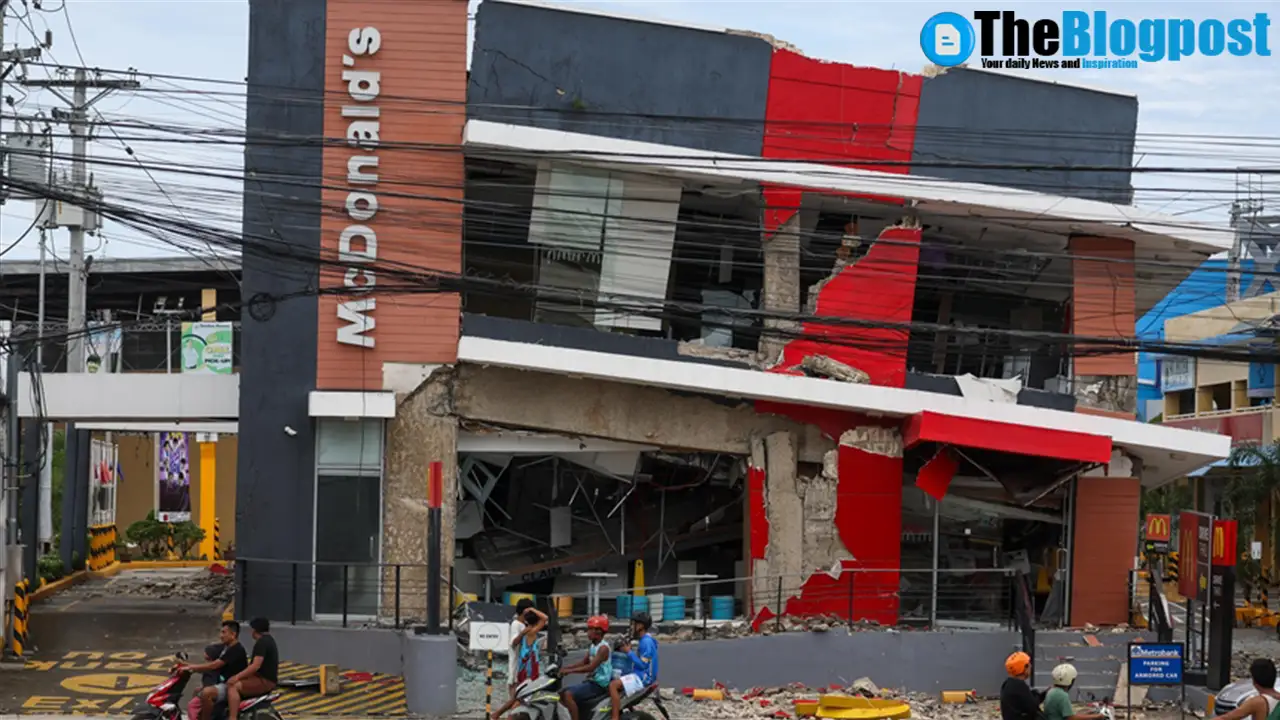
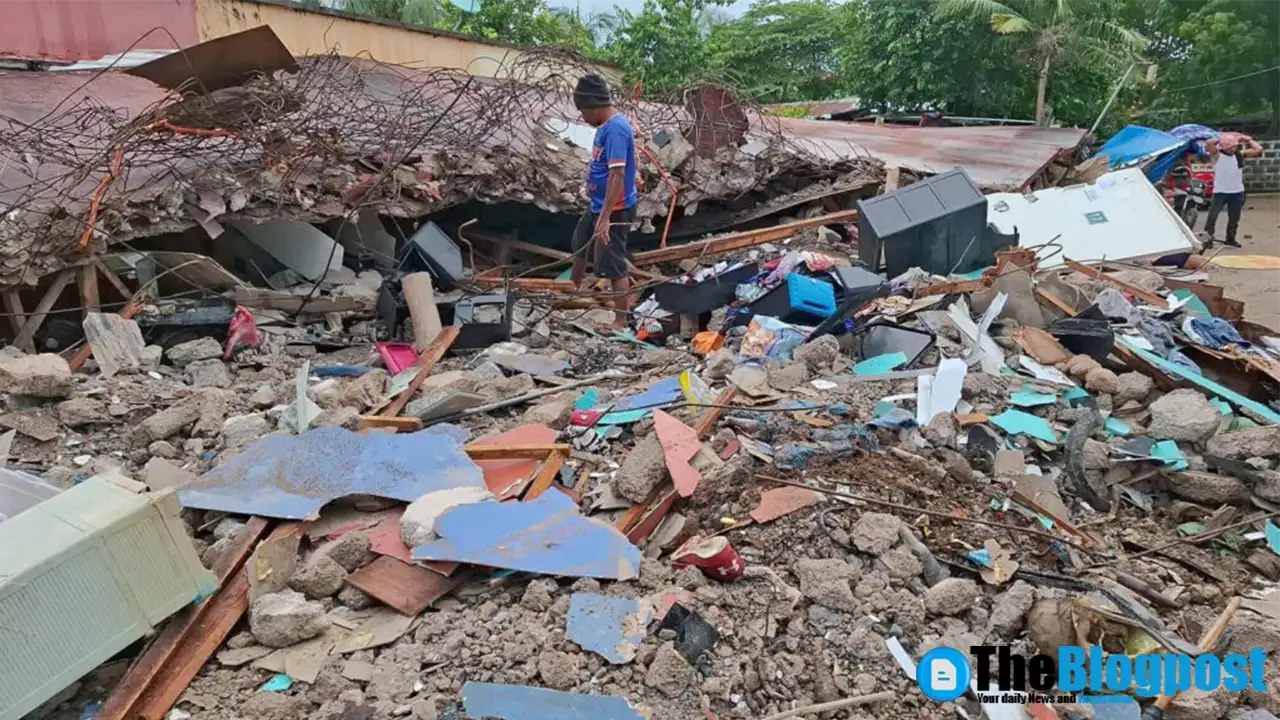
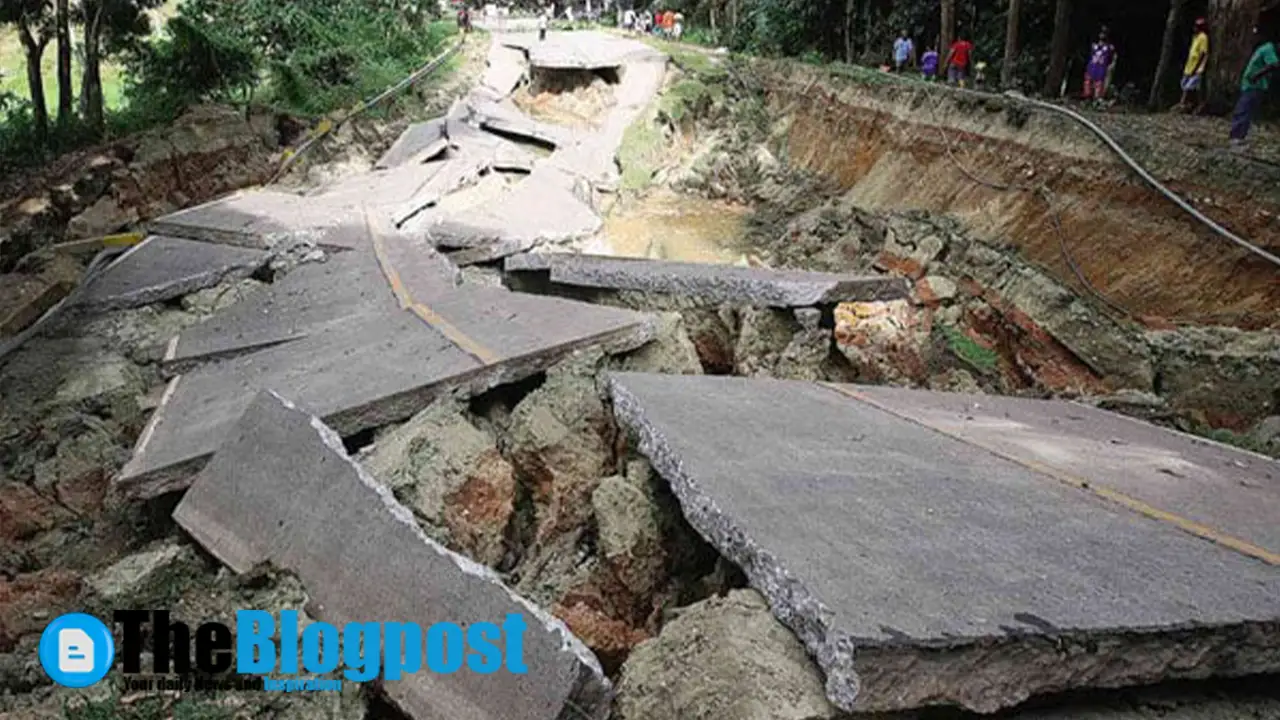
Scenes From Northern Cebu
Damage & Lifelines: What Was Hit and What Recovered First
The earthquake in Cebu Philippines damaged residences, municipal buildings, churches, and a sports venue, while disrupting road links and sections of the local power grid. Although lifeline crews restored partial electricity in several towns within 24–48 hours, isolated pockets remained offline longer due to safety inspections and landslide clearance. Heritage assets—particularly older masonry—saw disproportionate failure, which is typical under shallow, high-intensity shaking.
On the maritime side, authorities assessed port facilities for quay and fender damage; simultaneously, bridge inspections prioritized pier scour and bearing displacement checks. Schools served as both evacuation centers and staging grounds for relief distribution, which, in turn, allowed barangays to re-open main thoroughfares more quickly.
The Science: Faulting, Depth, and Aftershock Behavior
PHIVOLCS’ primer attributes the mainshock to strike-slip motion on a previously unnamed offshore fault segment. Because the rupture was shallow and near coastal communities, intensity values spiked despite a moderate magnitude. Inevitably, the aftershock sequence was robust; PHIVOLCS logged numerous events—including felt tremors—in the first 72 hours. Residents were urged to expect continuing aftershocks and to avoid damaged structures until cleared by engineers.
For residents and planners, the earthquake in Cebu Philippines is a reminder that seismic risk is not confined to long-mapped faults. Offshore segments can remain silent for centuries and then release accumulated strain suddenly, producing high local intensities and complex damage patterns. Consequently, updated microzonation and building code enforcement will be vital in northern Cebu’s rebuild.
Government Response and Relief Operations
National leadership visited Cebu to coordinate relief, while agencies stood up shelter and WASH (water, sanitation, hygiene) support for displaced families. International partners signaled assistance, and humanitarian briefings documented needs ranging from tarpaulins and sleeping kits to generators and satellite connectivity for command posts. As always, logistics corridors and weather conditions shaped the speed of delivery.
Over the next week, engineers will red-tag or green-tag critical facilities, prioritize hospital retrofits, and publish rapid visual assessment summaries. In parallel, social workers and mental-health professionals will continue outreach at evacuation centers, because the psychological footprint of the earthquake in Cebu Philippines is significant—especially for children and the elderly.
Safety First: What Residents Should Do After a Major Quake
- Expect aftershocks; move carefully around damaged buildings and avoid re-entry until structural clearance is issued.
- Use text/online messaging to free voice lines for emergencies; charge devices at community hubs where possible.
- Track official channels (PHIVOLCS and LGUs) for advisories on closures, water safety, and hazard zones.
- Document damage for insurance and assistance; photograph before cleanup where safe to do so.
- Seek psychosocial support if anxiety or sleep disturbance persists; many centers have dedicated teams.
What This Means for Risk Management in Central Visayas
The earthquake in Cebu Philippines will likely accelerate three policy tracks. First, microzonation for northern Cebu’s coastal towns will be refined using updated ground-motion models and landslide inventories. Second, retrofit programs for older masonry and essential facilities will gain urgency, especially for school buildings and clinics. Third, public drills and early-warning literacy will expand beyond Metro Cebu, since last-mile messaging during nighttime events proved pivotal for survival.
From a development perspective, resilience investments—elevated evacuation routes, redundancy in power/water, and robust telecom failovers—have outsized returns when shocks hit at night. Therefore, rebuilding plans should avoid “like-for-like” replacement and, instead, target risk-reduced designs that anticipate future events of similar magnitude near populated coasts.
Key Questions Answered
Was there a tsunami? An initial warning was discussed, but no major tsunami was ultimately reported; coastal vigilance remained in effect as a precaution.
Where were impacts worst? Northern Cebu—particularly Bogo City and surrounding municipalities—reported the most severe damage due to proximity to the epicenter and slope conditions.
What aftershocks should residents expect? PHIVOLCS recorded numerous aftershocks and advised the public to remain cautious for days to weeks after the mainshock.
Conclusion: From Shock to Strategy
The earthquake in Cebu Philippines was powerful, shallow, and tragically timed. It inflicted casualties and caused substantial, diverse damage—from heritage sites to homes—across Northern Cebu. Yet, as response transitions to recovery, the region has an opportunity to rebuild smarter: retrofit what can be saved, replace what cannot with hazard-aware designs, and invest in drills and communications that work even at 22:00 on a storm-soaked night. If those lessons stick, Central Visayas will be better prepared when the ground inevitably shifts again.


Leave a Reply